Hypothesis
PART I
THE NAZCA GREAT CIRCLE MAP HYPOTHESIS
By The Nazca Group
The lines and geoglyphs carved into the Nazca plateau represent a map of the Earth. The map is a Great Circle Map: a gnomonic projection with the center of the Earth as its cartographic view point. Each line on the Nazca Plateau represents a great circle of navigation centered at the center of the Earth and encircling the entire planet. The majority of the lines on the Nazca Plateau radiate from five loci of origin called radial centers. The five radial centers are labeled C, A, T, G and R on the complete blueprint of the Nazca Map-Plateau as presented in Plate-1. Each radial center represents a specific geographic location on the surface of the Earth. The unicursal geoglyphs drawn amidst the straight lines function as eco-geographical markers—each figure representing a different geographic region of Earth. Using the geoglyphs as guides one can orient the Nazca map and infer the precise geographic locations of the radial centers on Earth. Once the exact radial center locations are known, the lines of the 2-Dimensional map-plateau can be projected as 3-dimensional great circles that circumscribe Earth.
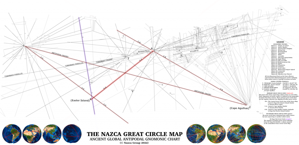
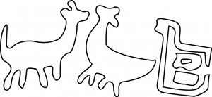
To orient or key the Nazca map one begins with the geoglyph that depicts two llamas (Figure-1). The figure on the right of the llamas, often referred to as their “pen” or “corral”, will be addressed in a later work. The llamas suggests a clear and particular association with South America, specifically with the Andean region where the map itself is found. Therefore the llamas geoglyph is cartographically assigned as representing the Nazca-Andean region of Earth.
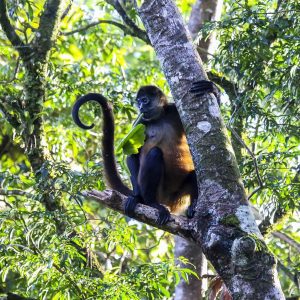
The nearest geoglyph easward of the llamas is that of a spider-monkey seen in Picture-1 and Figure-2. The monkey appears hanging inverted from a jagged line formation that resembles a mountain chain, suggestive of the Andes mountains. This is geographically reasonable—as one moves eastward from Nazca over the Andes mountains one drops into the western Amazon Basin, where spider-monkeys abound. The spider-monkey glyph is therefore cartographically assigned to the southwestern region of the Amazon Basin.
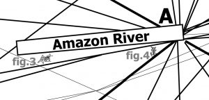
Northward from the spider-monkey one finds the geoglyph called the grampus, or dolphin (Figure-3). The dolphin figure borders the southwestern edge of a large quadrangular polygon, labeled “Amazon River” on Plate-2. One tends to associate dolphins with oceans, yet before one reaches the Caribbean Sea to the north of the Amazon, one encounters a particular and anomalous species of dolphin: the Amazon River Dolphin. These fresh water dolphins inhabit the western headwaters of the Amazon River.
Considered thus, the Amazon River Dolphin figure becomes a highly specific identifier for the Amazon River – the largest river of Earth – allowing one to infer that the large rectangular polygon adjacent to the river dolphin is a cartographic representation of the Amazon River itself. From this inference one may further infer that: all polygonal and triangular geometric shapes on the Nazca map are cartographic representations of rivers and water ways. The shallow tapering of the Amazon River Polygon towards its western end—is suggestive of the easterly flow of the Amazon River current—leading to an additional hypothesis: water currents flow in the direction of widening of polygonal or triangular figures.
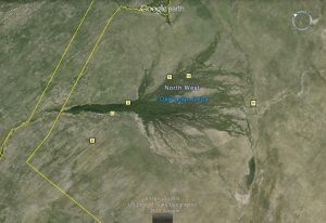
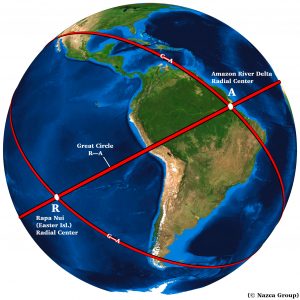
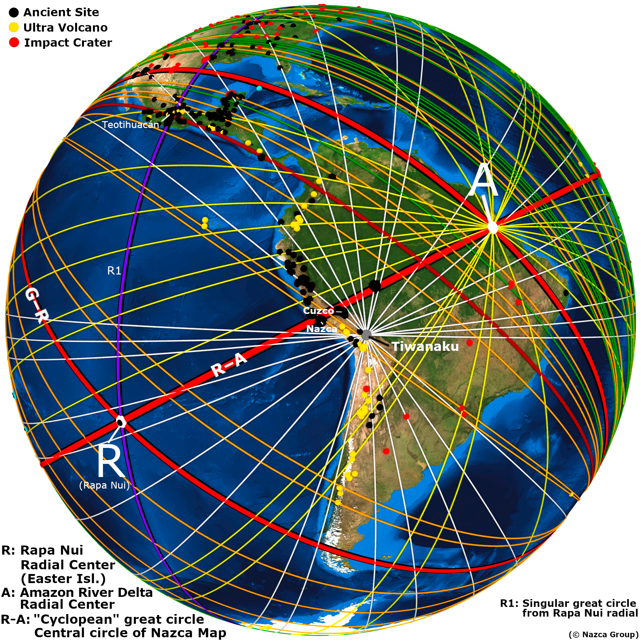
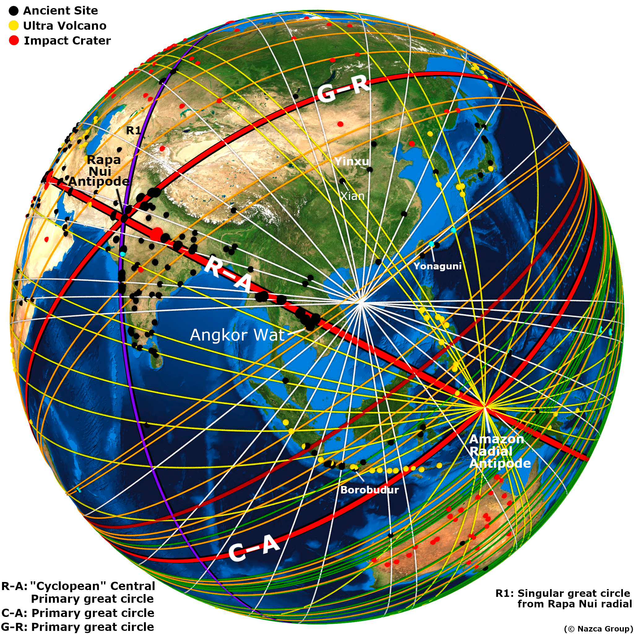
Eastward from the river dolphin, towards the eastern end of the Amazon River Polygon is the figure of a downward diving fish (Figure-4). The downward orientation of the fish is suggestive of the Amazon River waters “falling” into the Atlantic Ocean. We therefore cartographically assign this fish to the Amazon River Delta region. Directly beneath the easternmost end of the Amazon River quadrangle is the radial center labeled “A” on Plate-2. The mouth of the Amazon River occurs at the terrestrial Equator—providing a “natural” cartographic location that allows one to infer the geographic location of the first radial center. The Amazon Radial Center (A) is therefore assigned equatorial coordinates at the center of the largest island in the Amazon River Delta: 0 North, 50 West.
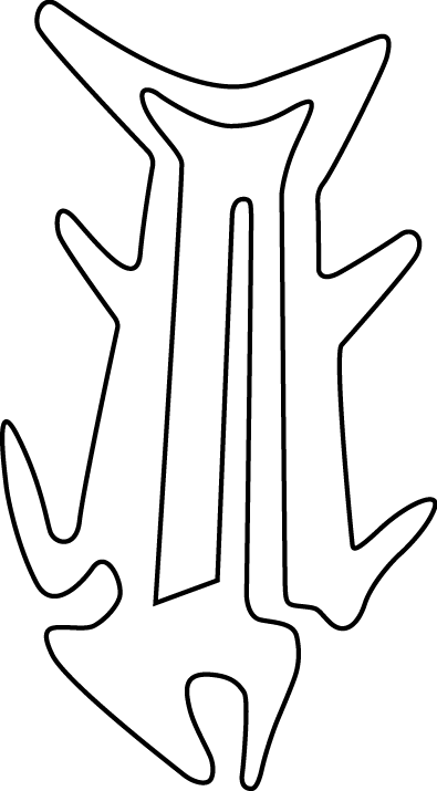
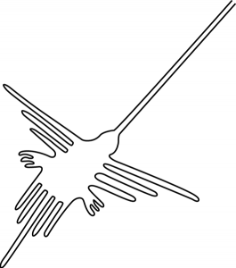
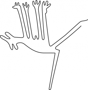
Towards the northwest of the Amazon River radial center is the geoglyph of a hummingbird (Figure-5). These birds are unique to the Americas and exist in abundant numbers and variety in the Northern Amazon and Central American region, as indicated by the figure’s relative position in relation to the Amazon River

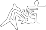
Southward from the Amazon River is the figure commonly misidentified as a dog (Figure-6). The rounded ears and its inverted “hanging” orientation are strongly suggestive of a Tamandua, a semi-arboreal mammal that is unique to South America, inhabiting a vast range of forests and savannas south of the Amazon River (Picture-2).
To the southeast of the Amazon River polygon is the geoglyphic figure often called a condor (Figure-7). From a biological standpoint the figure lacks all bird of prey characteristics. The beak and legs are too long and thin, not short and robust like a condor’s, and it lacks the large wing span in relation to the tail. The bird represented is actually a Willet—a coastal bird that ranges the Atlantic coasts from southern Brazil to the coasts northward of Florida (Picture-3). When viewed from above, flying low along the shore, Willets look very much as depicted by the geoglyph drawn on the plateau. Willets are unique to the eastern shorelines of the Americas, indicating that eastward from this point is the Atlantic Ocean.

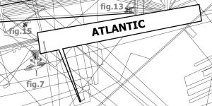
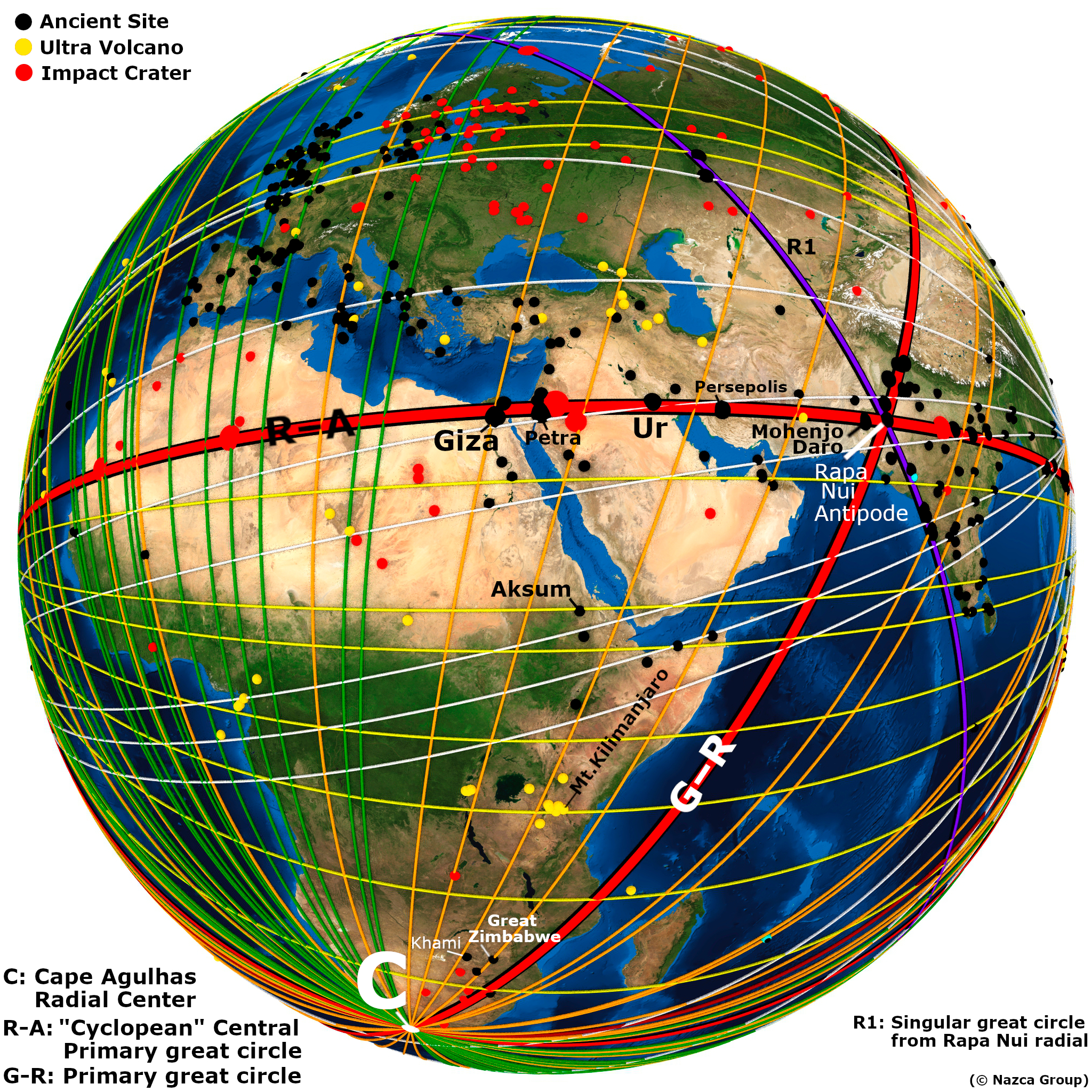
Adjacent to the northeast of the willet and spanning eastward is a large polygonal shape labeled “ATLANTIC” (Plate-3). Adhering to the hypothesis that polygons and triangles represent water-ways, the large polygon must represent a portion of the Atlantic Ocean—from the easternmost shore of South America to the western shores of the African continent. The sub-hypothesis that water currents flow in the direction of polygonal widening finds congruency—the Atlantic South Equatorial Current flows westward from the Bight of Africa towards South America’s easternmost shore—as indicated by the Atlantic polygon widening towards the west. Further eastward on the map, beyond the Atlantic polygon is the geoglyph often referred to as a lizard (Figure-8, Plate-4). The long narrow snout is more representative of a crocodile and of the Bight of Africa.
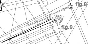
Towards the south of the crocodile in Plate-4 is the figure commonly referred to as a tree, seen in Figure-9. The figure is drawn at the eastern end of a long thin triangle. Trees are not the only natural phenomena with “branching” morphology. Following the sub-hypothesis that the triangles and trapezoids represent waterways, and the fact that the figure in question is found at the end of a long narrow triangle, suggests that there is a unique element south of the Congo region and at the end of a water way with an eastward inland flow, as indicated by the triangle broadening towards the East.

The unique element in question must be the anomalous Okavango River Delta (Picture-4). The Okavango River and its delta are geographic anomalies—the Okavango River the only major river on Earth that flows inland, away from the sea to empty into the African savanna. As the only major river on Earth with an inland river delta—its uniqueness provides a highly specific geographic location. Even in our present day, from a high vantage over modern day Botswana, the Okavango River Delta bears an uncanny likeness to the delta geoglyph.
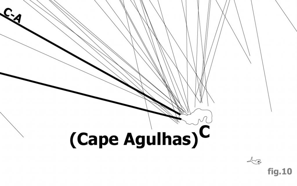
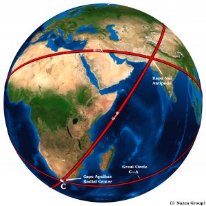
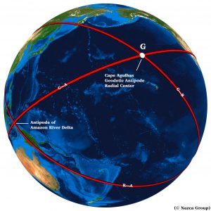
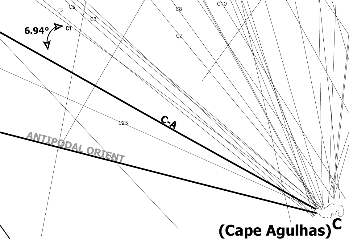
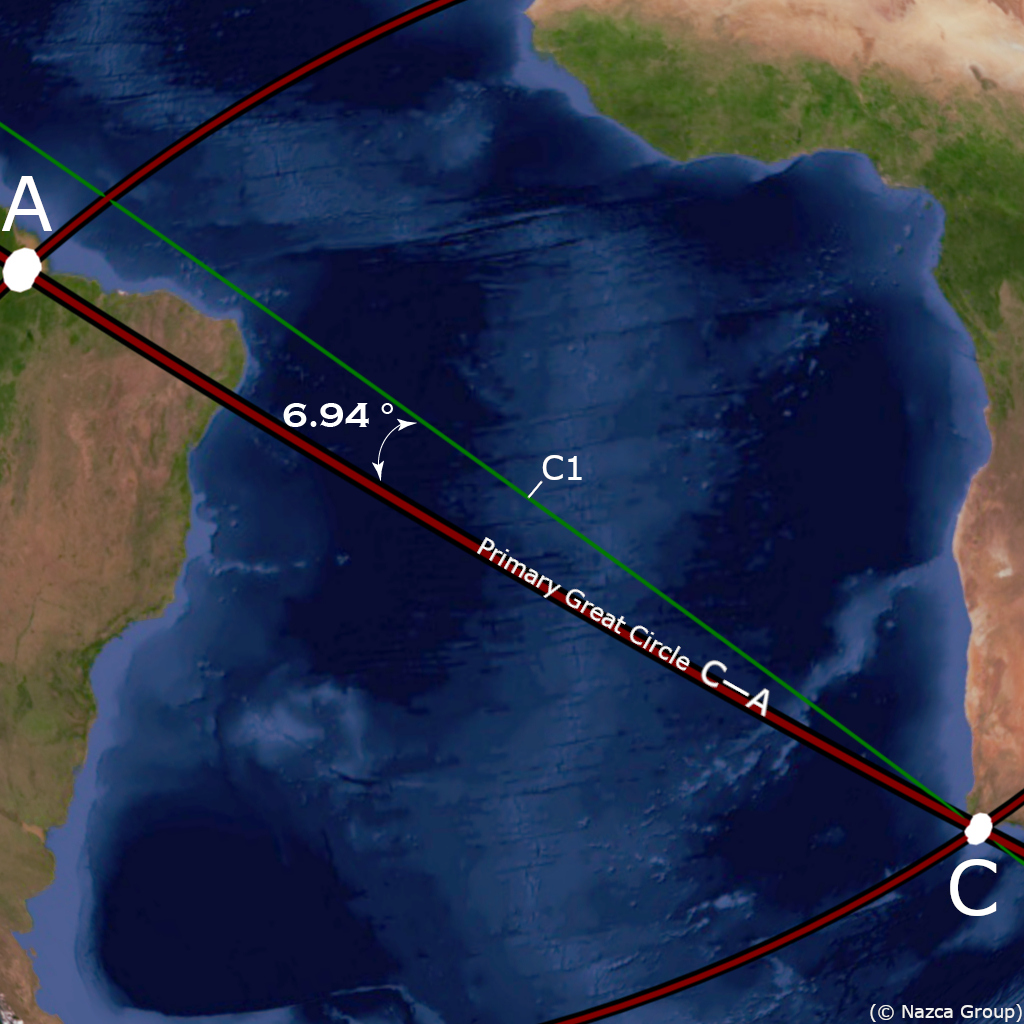
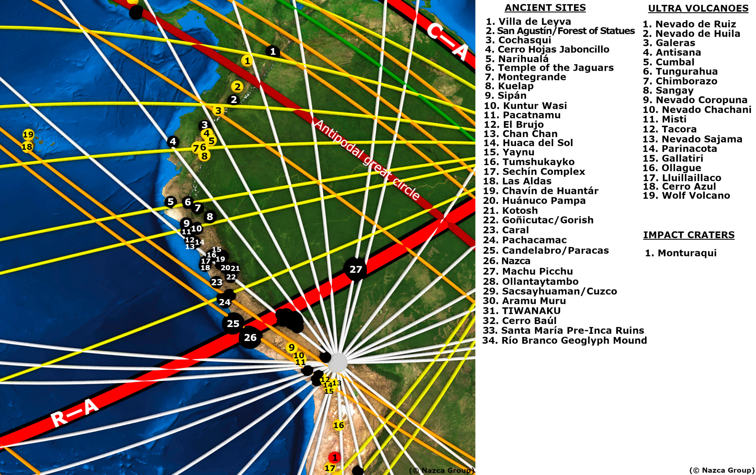
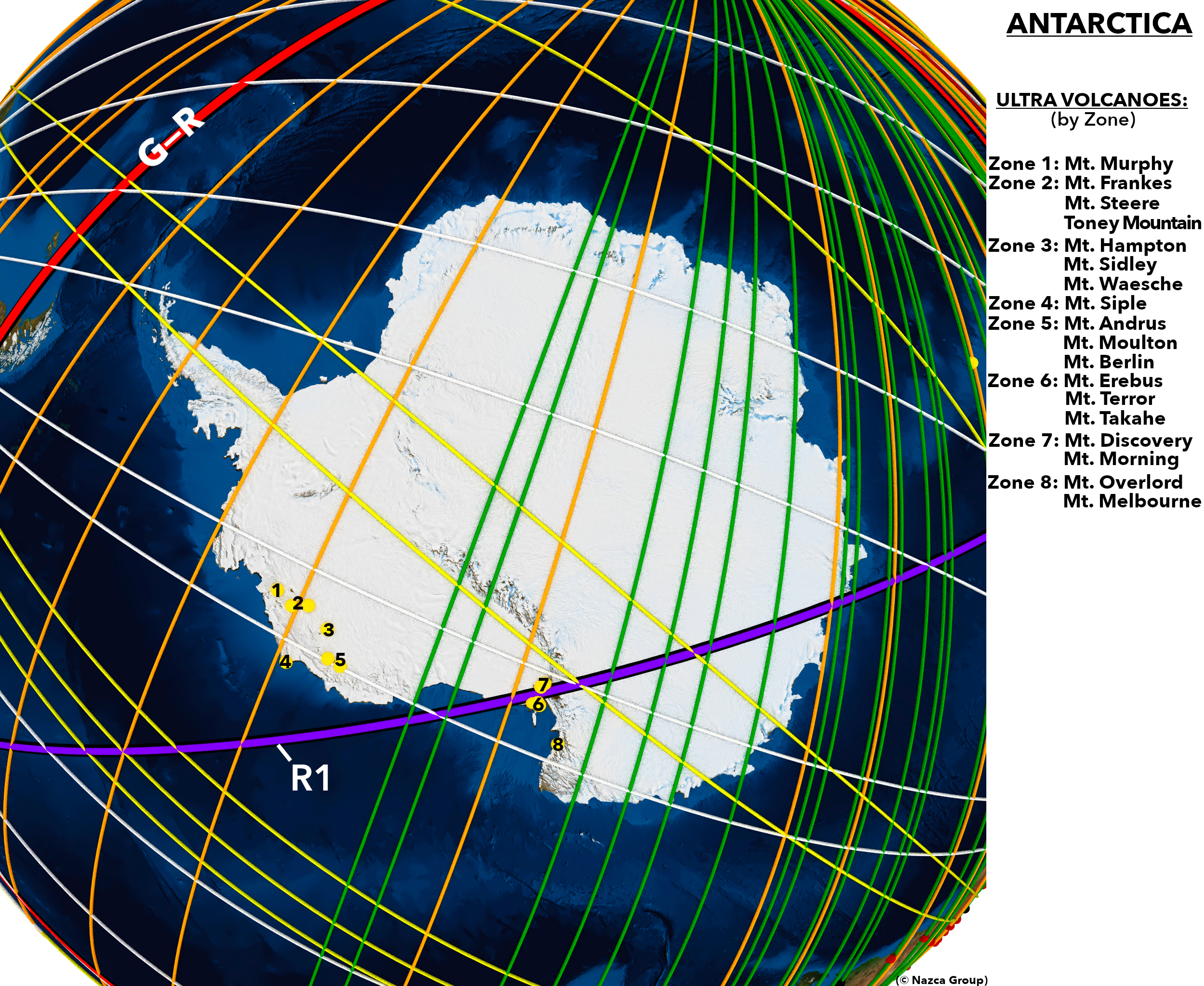
South of the Okavango Delta numerous lines converge at the easternmost radial center of the Nazca map, labelled “C” on Plate-5. Further south the figure of a Right Whale (Figure-10) suggests the Southern Ocean. The location of the radial center is therefore somewhere south of the Okavango River Delta yet north of the Southern Ocean—at the southern end of the African Continent. The African continent reaches its southernmost geographic extreme at “Cape Agulhas”, Portuguese for “Cape Needles”. The topography of the cape narrows southward into a specific and precise geographic location (Picture-5). The Cape Agulhas Radial Center (C) is therefore assigned the coordinates at southernmost point of the African continent: 34.839 South, 20.004 East.
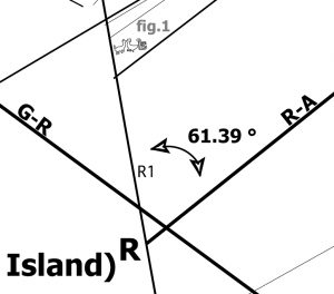
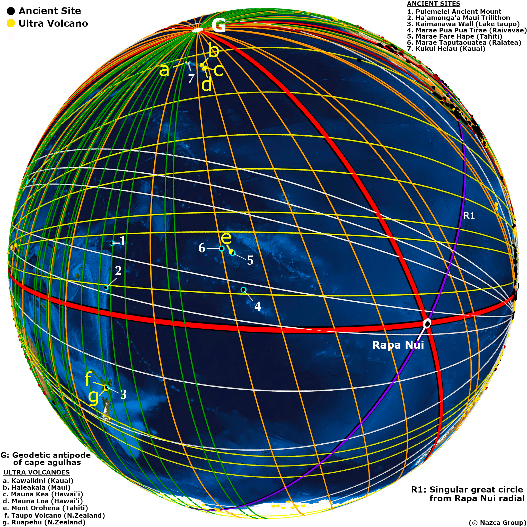
Having identified the easternmost radial center at Cape Agulhas, we return westward to the radial center composed of only three lines, forming a triangle, as shown in Plate-6. The triangle’s location south of the Andean llamas may suggest that the radial center in question is within the South American continent or near its western shoreline. Yet its apparent location on Plate-1 in relation the Amazon River suggests a location a considerable distance to the southwest—in the South Pacific Ocean. The reason for the cartographic ambiguity in the location of figures will be addressed in a later work. There is a rather famous and anomalous island in the South Pacific Ocean with triangular topography—the island of Rapa-Nui, commonly known as Easter Island as seen in Picture-5.
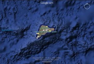
Easter Island is considered one of the most geographically isolated islands on Earth—having wide expanses of ocean between itself and other shores. It is also the location of the anomalous cyclopean stone monuments known as Moai. The Rapa-Nui Radial Center (R) is therefore assigned a location at the geometric center of Easter Island: 27.109 South, 109.366 West.
To the northwest of Easter Island is the map’s westernmost radial center, labelled “G” on Plate-1. There are no geoglyphic figures in this part of the map to give eco-geographic clues to identify the radial center. Its general cartographic location far to the northwest of Easter Island, suggests perhaps a location in the vicinity of the Hawaiian Archipelago, such as its highest point at the volcanic summit of Mauna Kea. This would be a reasonable proposition in keeping with the theme of the anomalous extreme—measured from its base at the bottom of the ocean, Mauna Kea is the tallest mountain and largest shield volcano on Earth. Before settling on this conclusion, cartography itself provides yet another clue to infer the identity of the westernmost radial center.
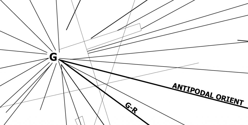
The extremely long line labelled “Antipodal Orient” in Plate-1 and Plate-7 connects the easternmost radial center at Cape Agulhas with the westernmost radial center in question. This line is categorically different from other lines—connecting the two distal non-adjacent radial centers—suggesting an elementary cartographic relationship between them. Their positions at opposite ends of the primary grid indicate that the radial centers are Geodesic Antipodes—representing locations on exact opposite sides of the Earth. The antipode to Cape Agulhas is a point on the Pacific Ocean north of the Hawaiian Islands. The westernmost radial center is therefore assigned the geographic coordinates at the Geodesic Antipode to Cape Agulhas (G): 34.839 North, 159.996 West.
The lines that connect adjacent radial centers are called primary lines. The primary lines form the primary grid of the map and are drawn as wider lines on Plate-1. The primary lines are named and labelled according to the radial centers they connect: G-R, R-A and C-A. The primary lines represent primary great circles that can be projected into virtual orbital imagery as shown in Image-1, Image-2 and Image-3.
This primary grid of great circles is the key anchoring element of the Nazca map. The lines of the primary grid represent primary great circles that transect the geographic locations of the radial centers. The angular alignments of these primary great circles are geographically determined by the radial centers they transect.
The numerous other lines that radiate from the radial centers are called secondary lines. The secondary lines represent secondary great circles that are angularly aligned in relation to the primary great circles of the primary grid.
The Antipodal Orient great circle transects antipodal radial centers and therefore is therefore not locked into a determined alignment. The Antipodal Orient great circle, as its name implies, follows the Orient Rule—the Antipodal Orient great circle is aligned to East-West at Cape Agulhas. It is a property of great circles to mirror the angular alignment at any antipodal point—therefore the angular alignment of the Antipodal Orient great circle is also East-West at the antipode (G) to Cape Agulhas. Before projecting the antipodal orient great circle, or any other secondary great circles of the map, we draw attention to the last radial center—at the central and capital position on the map—the radial center labelled “T” on Plate-1 and Plate-8.
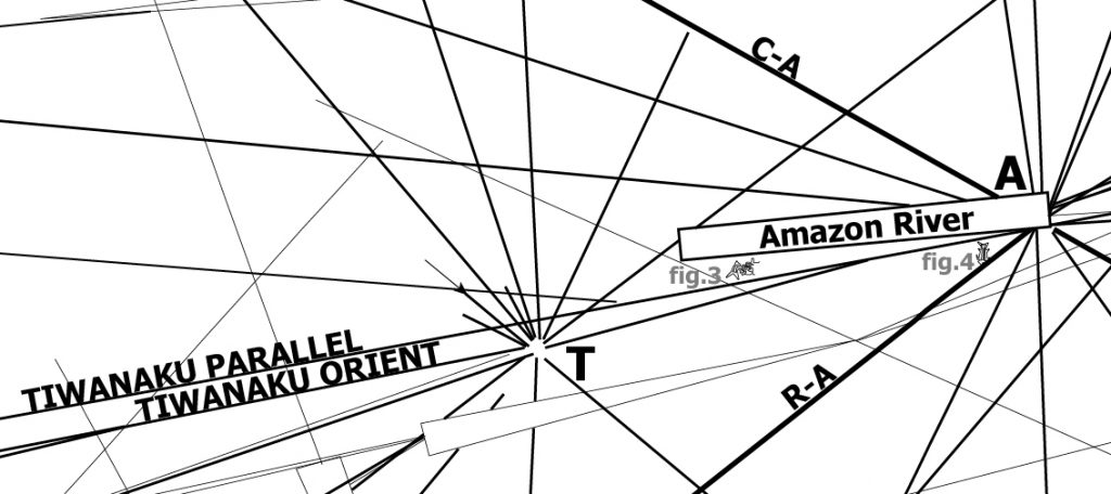
Its central position suggests the raspdial center is somewhere in the vicinity of the Nazca Plateau itself. Not far from Nazca is another unique and monumental terrestrial anomaly—Lake Titicaca. Lake Titicaca is the highest lake on Earth and its salty water a remnant of its oceanic origins. On the shores of this anomalous and extreme lake are the ruins of the most elevated ancient megalithic structures—the ruins of Tiwanaku, the cradle of Andean civilization. The ruins are of enormous megalithic proportions and of great uncertain age. The Tiwanaku Radial Center is therefore assigned the geographic coordinate location of the largest central monument at the site—the Akapana Pyramid: 16.558 South, 69.657 West.
Upon close inspection the Tiwanaku radial center is categorically different from the other radial centers on the map—none of its lines directly connect to any other radial center. Tiwanaku is central in position yet disconnected from the primary grid, implicating it as the Capital of the Nazca Map. Yet this lack of connection to a second radial center leaves no reference to geographically anchor the angular alignment of its many radiating great circles. The situation is similar to that of the Antipodal Orient requiring the Rule of Orient. One must infer which line of the Tiwanaku lines represents the great circle aligned towards Orient—due East-West—at Tiwanaku. We call attention to another anomalous line labelled “Tiwanaku Parallel” seen on Plate-1 and Plate-8. The Tiwanaku Parallel is the longest line on the Nazca map-plateau. The Tiwanaku Parallel nearly transects the central Tiwanaku radial center, and truly transects the Amazon radial center. This anomalously long line cannot represent only a great circle from the Amazon radial center—for it tadiates on both sides of the radial and across the entire map. Any line that transects a radial center and radiates on its opposite side represents one same and single great circle. This cartographic anomaly of suggests an additional cartographic meaning. Further, the Tiwanaku Parallel runs in perfect parallel with a line labelled “Tiwanaku Orient “, seen in Plate-8. This cartographic paralleling of lines suggests that the Tiwanaku Orient Line represents a great circle that is angularly aligned to Orient—East-West—at Tiwanaku. All other great circles that radiate from Tiwanaku are angularly aligned in relation to the Tiwanaku Orient great circle. Since the Tiwanaku Parallel has a double function as a cartographic anchor for the Tiwanaku radial center yet must be counted as a great circle from the Amazon radial center, it is labelled “A-2” at the Amazon radial center and is included as a great circle of the 3-Dimensional map.
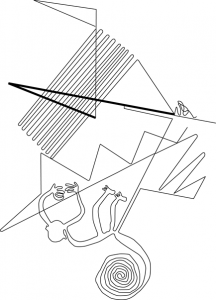
Having determined the three primary and Tiwanaku Orient great circles, one is ready to project all the great circles of the Nazca map. The method of angular measurement of secondary lines and their projection into great circles is graphically demonstrated in Plate-9, showing line C-1 measured in relation to primary line C-A and projected as a great circle in Image-4. The secondary lines from the other radial centers are similarly measured and projected in relation to the primary great circles. The method for each radial center is graphically demonstrated in the Data section of this work as well as numerical tables providing the angular alignments of all the Nazca lines and corresponding great circles.
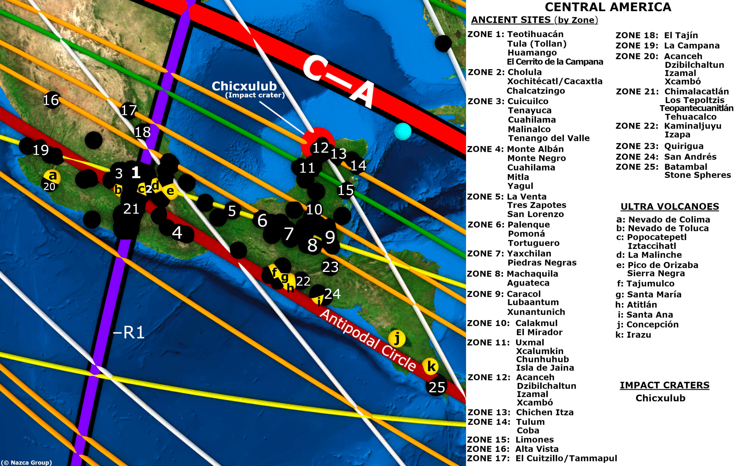
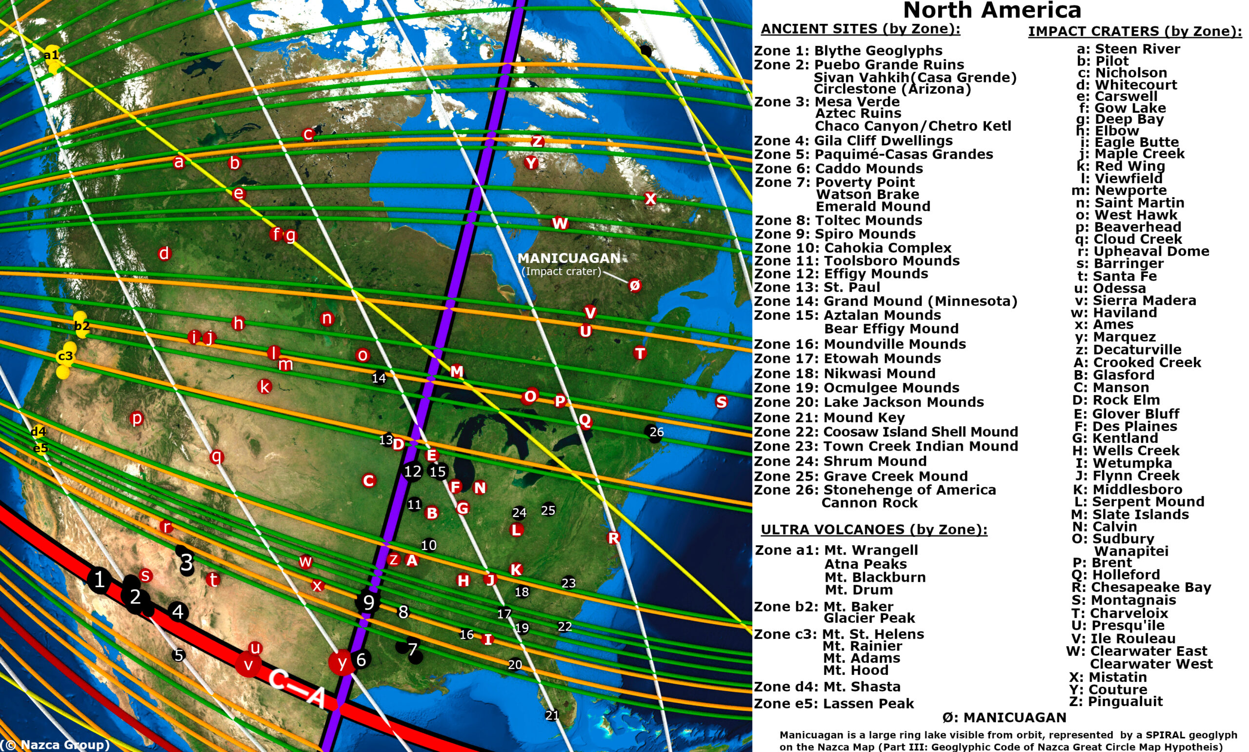
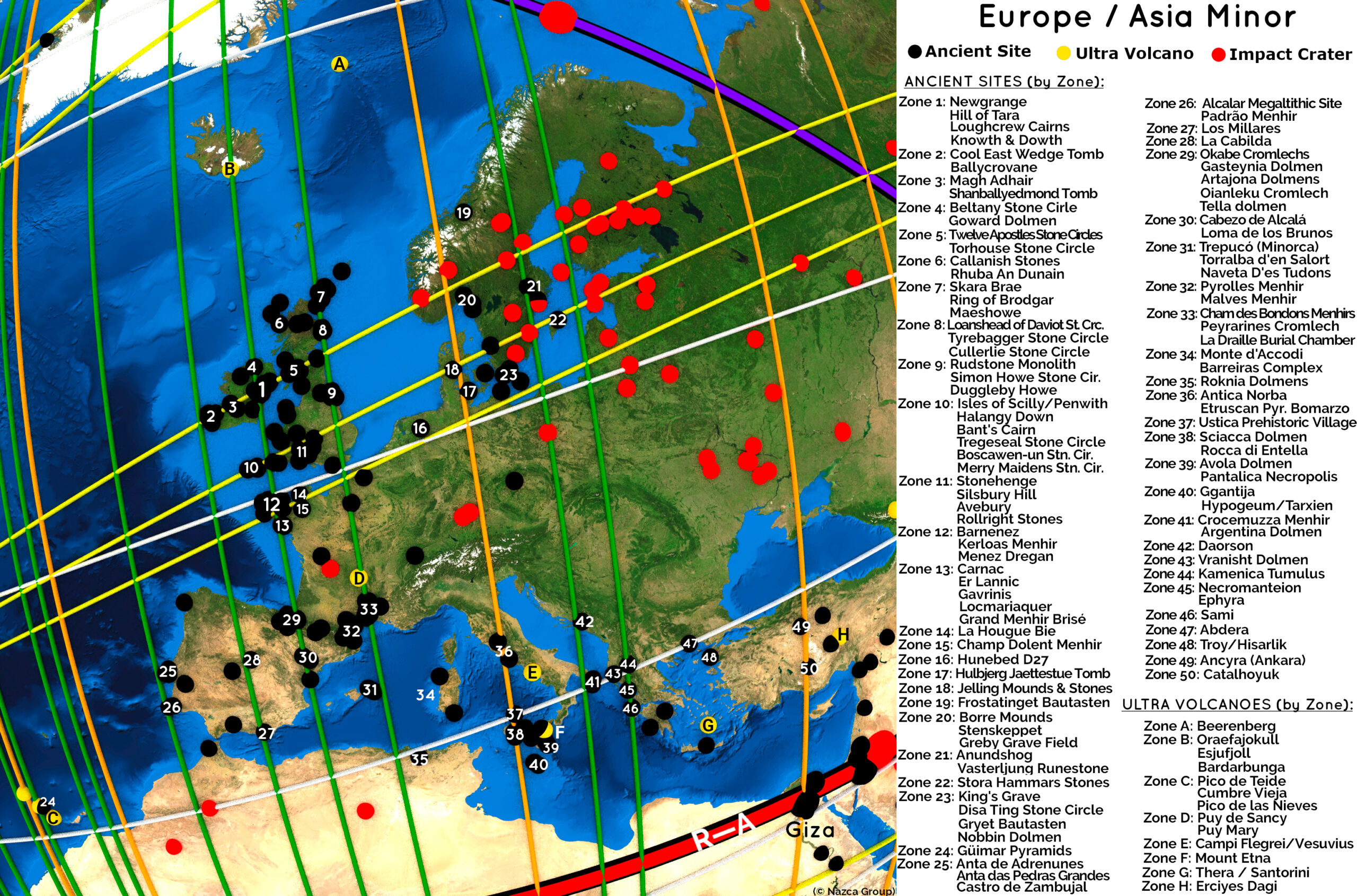
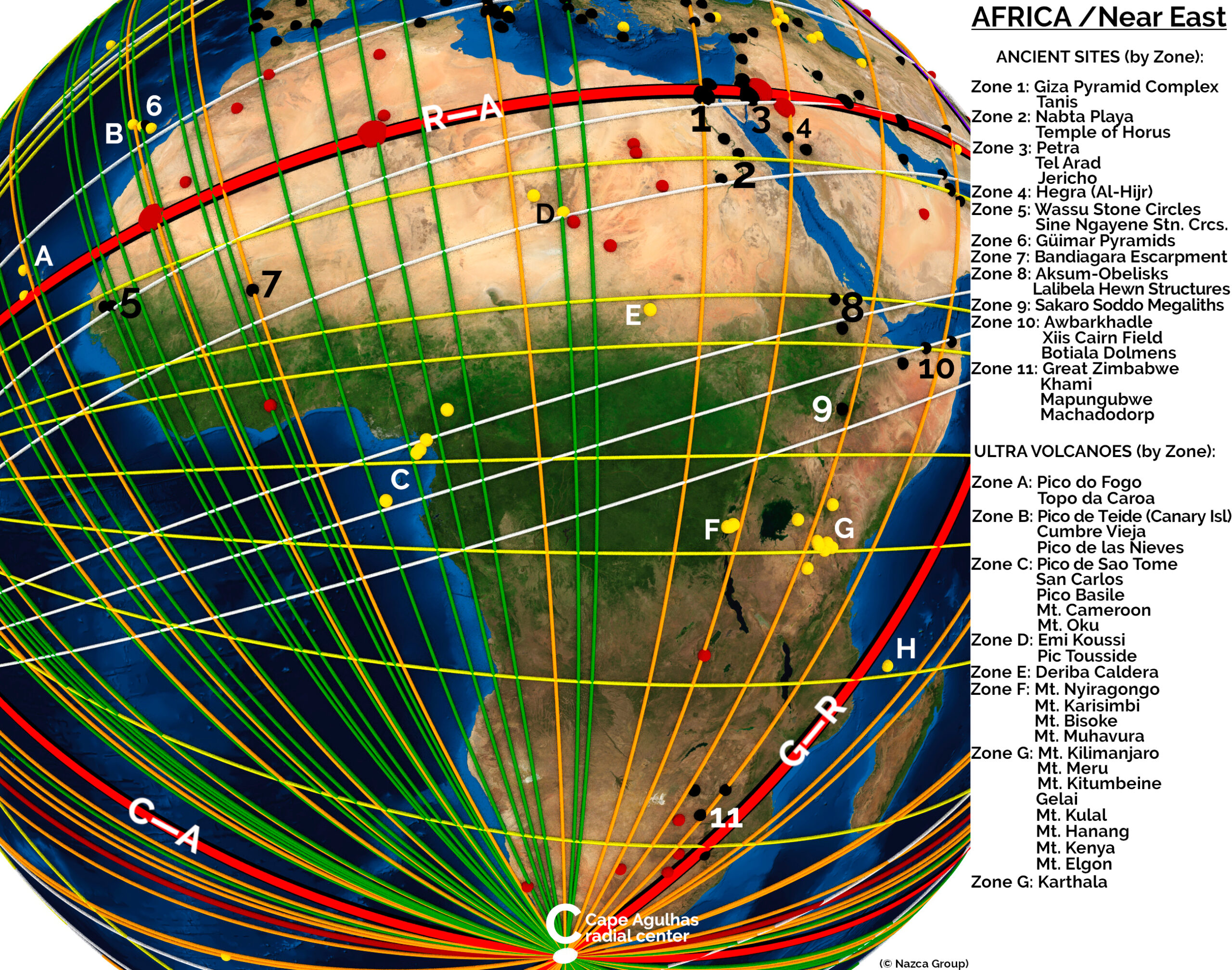
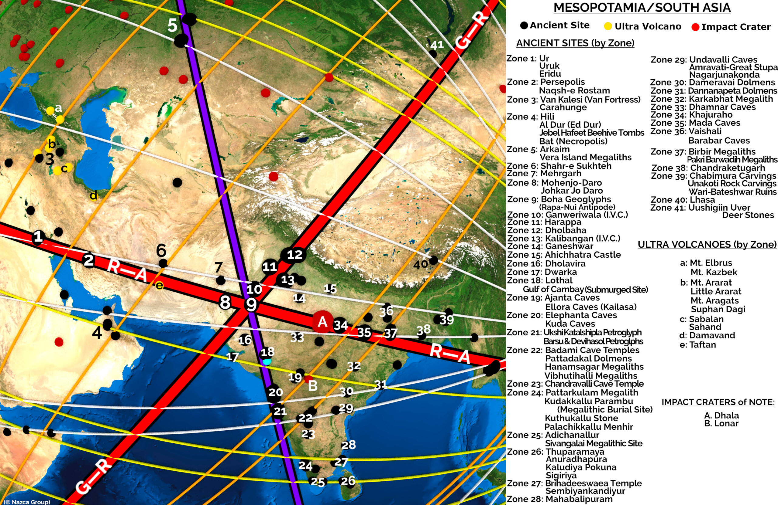
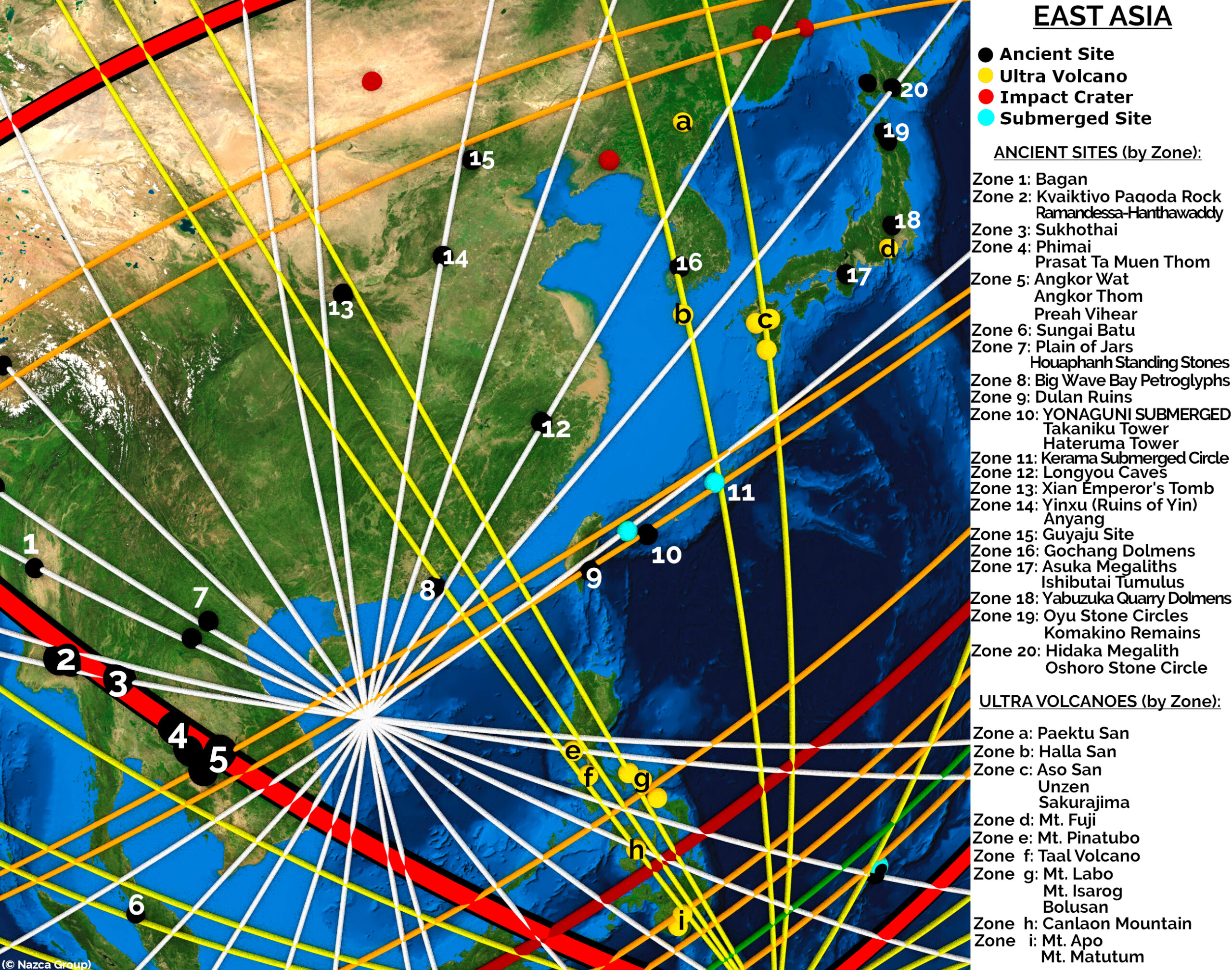
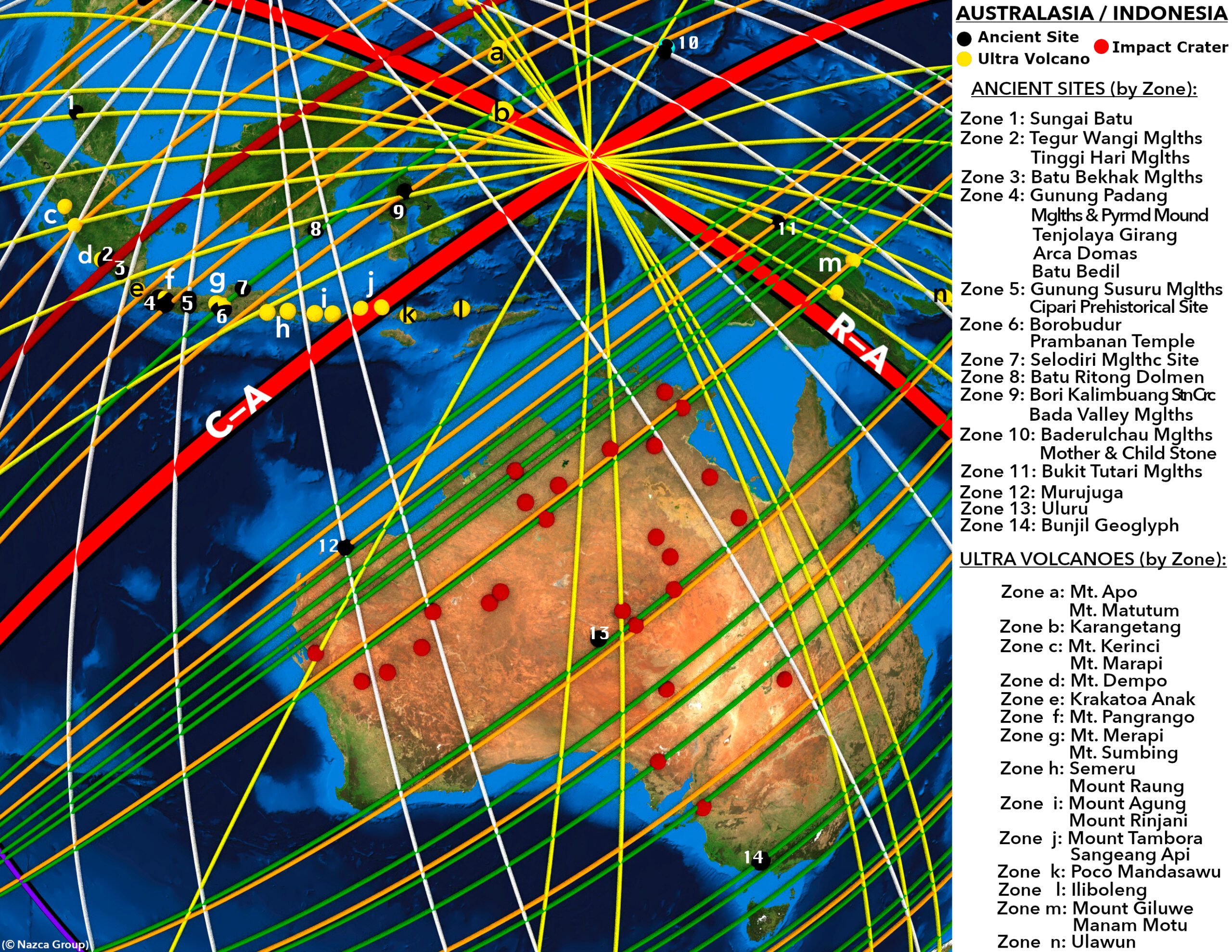
Before projecting the complete array of great circles of the Nazca map, we call attention to a pattern along the path of primary great circle R-A. The course of primary great circle R-A traverses the coast of Peru and nearly transects the Nazca Plateau itself. Further discernment reveals that along the path of great circle R-A are the ruins of many famous ancient monumental structures, shown in Image-5 to Image-8.
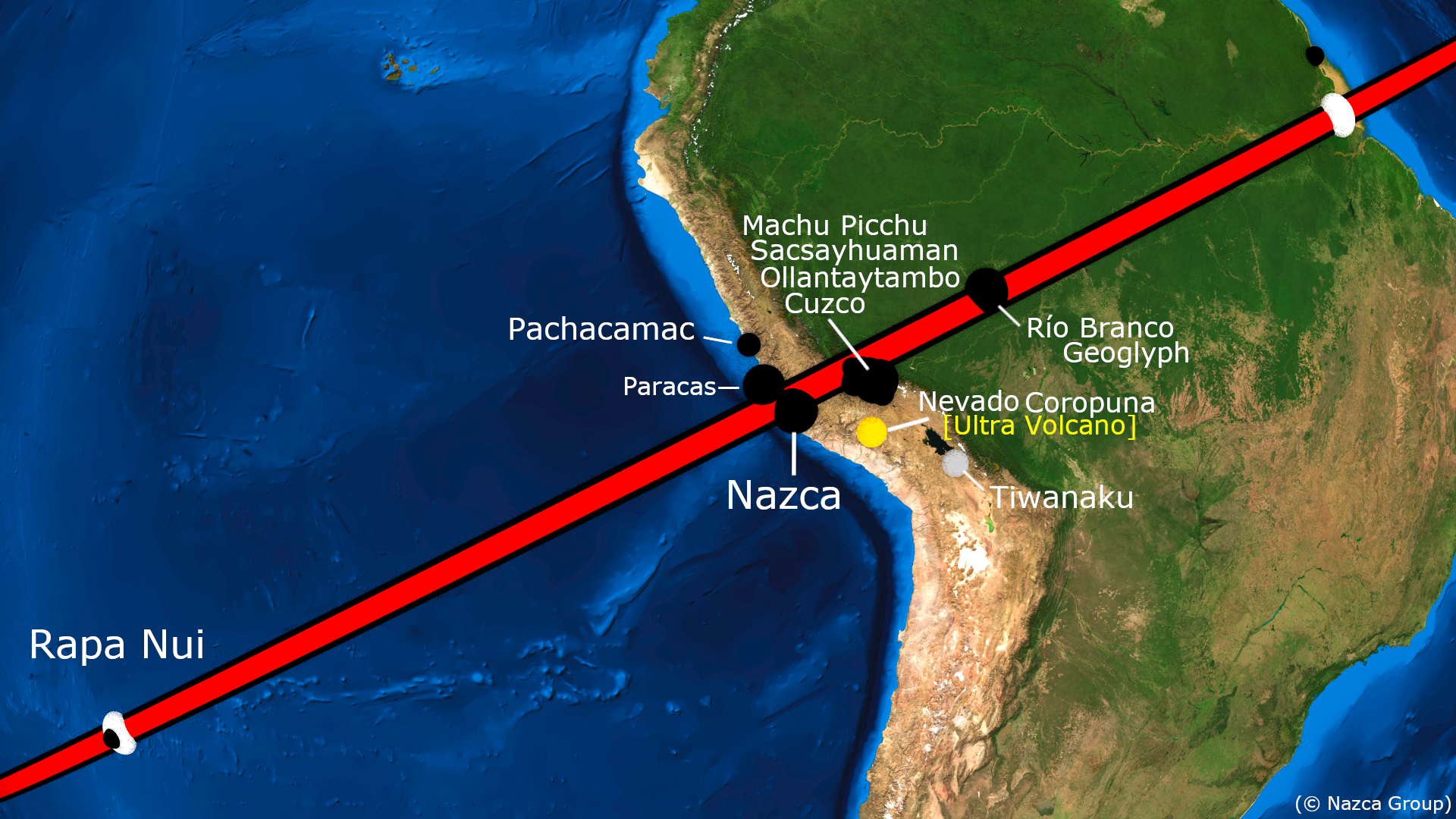
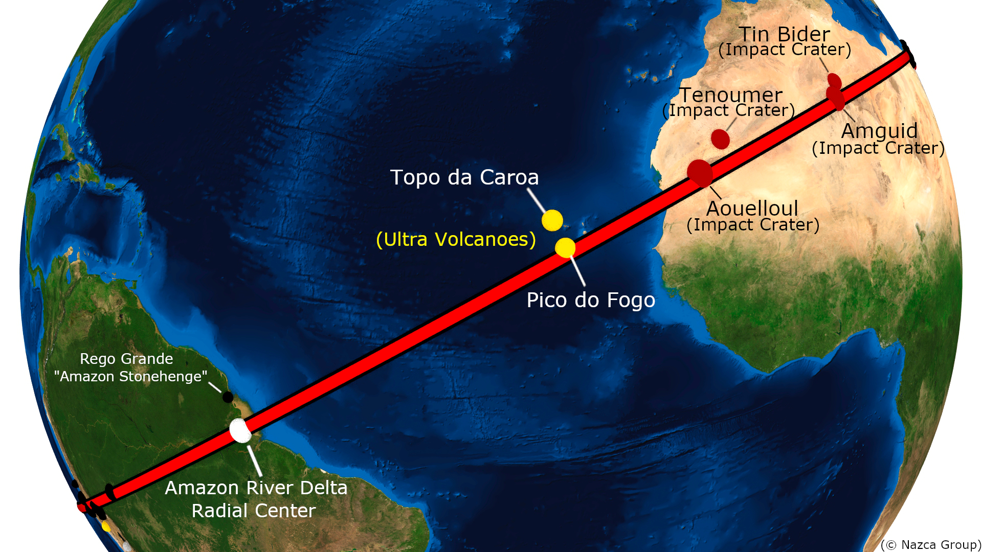
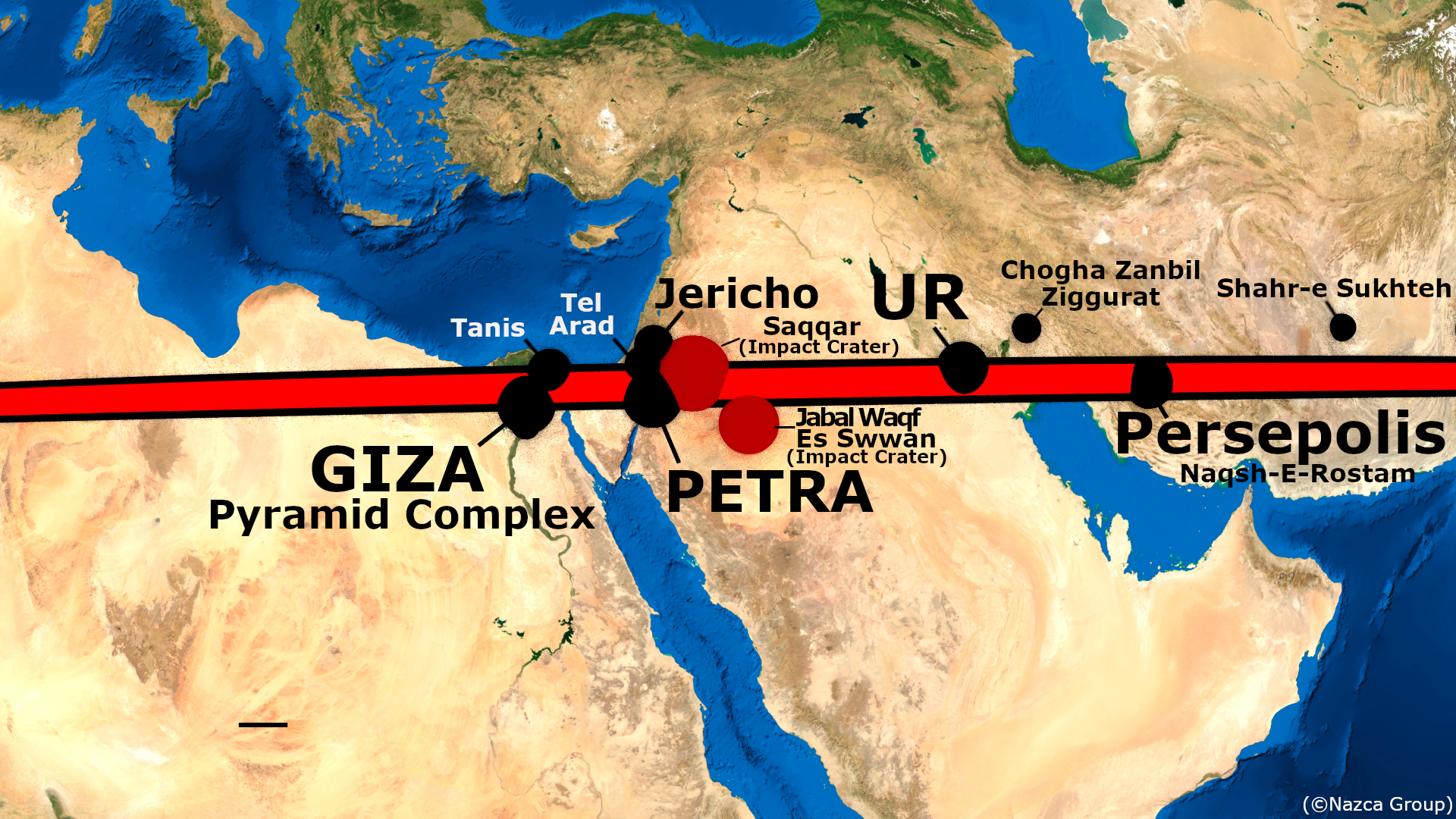
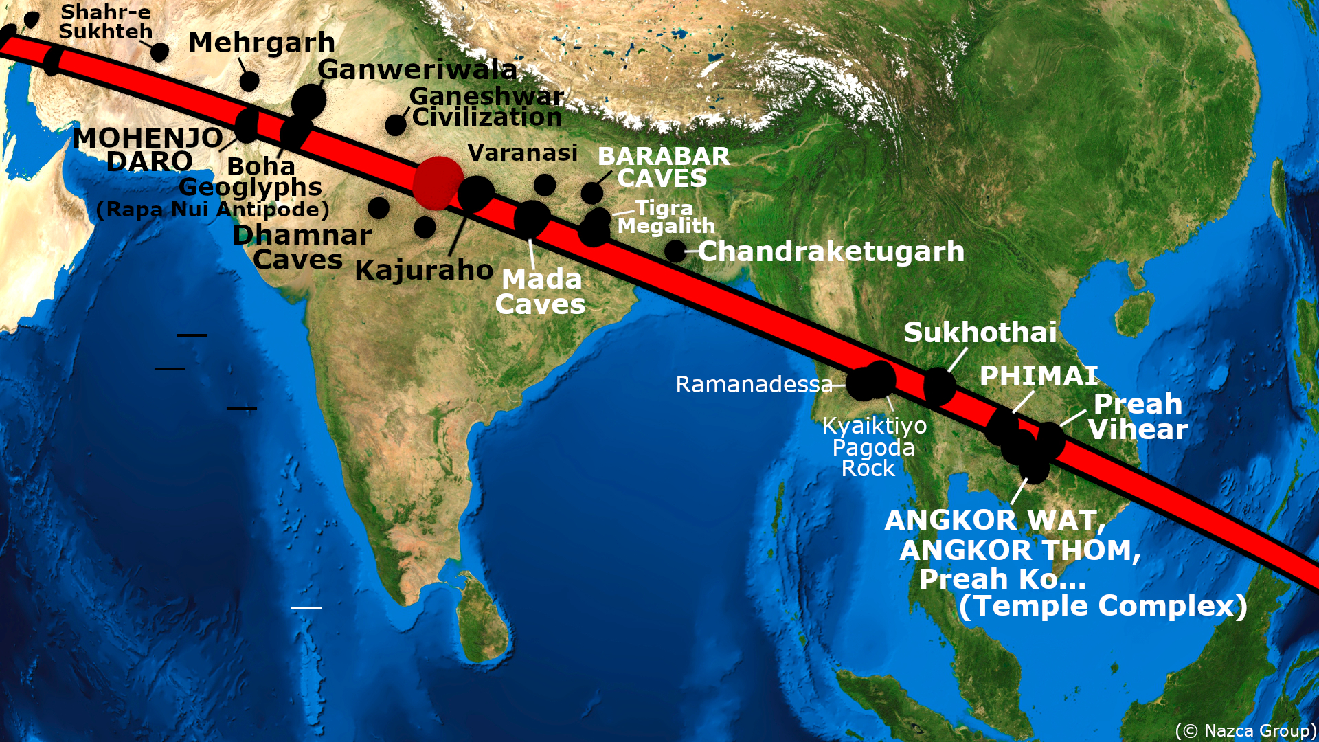
The virtual imagery shows the Nazca Plateau itself, Machu Picchu, Sacsayhuaman, the Giza Plateau, Petra, Ur and Eridu, Persepolis, Mohenjo-Daro, Angkor-Wat, and other ancient sites of great renown all in close geographic alignment with the great circle which completes its course at Easter Island and its ancient monolithic Moai.
In summary: A significant number of cradles of civilization and ancient sites of great renown are found along the course of primary great circle circle R-A.
This “Cyclopean” Great Circle—named thus after the gigantic scale of masonry and structural ruins found along its course—was first noticed by a man named Jim Alison. Alison had noticed the cyclopean and many other great circle alignments from the empirical evidence provided by the geographic locations of the sites themselves. Such great circle alignments of ancient sites had previously been ignored, as had their profound historical implications. Alison found that sites of import were located at equidistant intervals of geometric significance along the course of the cyclopean great circle. Other investigators such as Robert Bauval and Graham Hancock had previously noted equidistant longitude relationships between ancient sites of note, echoing Jim Alison’s findings. Jim Alison had strongly suspected that Nazca—itself a site in the Cyclopean Great Circle Alignment—represented a diagram of the great circles alignments. Jim Alison was not only correct, but was himself directly involved in the development of this present work, which owes much to his insight and collaboration.
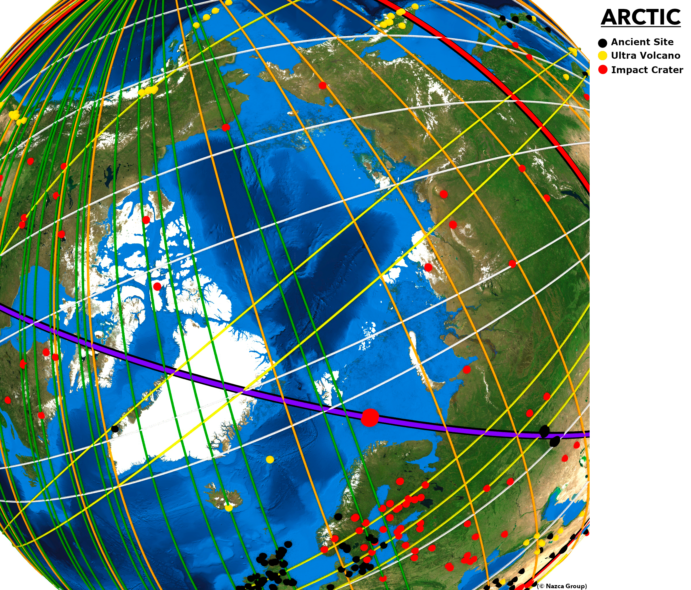
The purpose behind the great circle alignments of the ancient sites and the Nazca map becomes clearer when the other phenomena under the great circles are discerned: Impact craters and volcanic calderas. These two “cataclysmic” categories of phenomena are also in great circle alignment with the great circles of the Nazca map. A fourth category of submerged monuments includes submerged archeological sites of recent discovery or rumor that are found suggestively near the courses of the great circles of the Nazca map. The complete site list of all ancient monuments, volcanoes and impact craters and their geographic coordinates are provided in the sites section of this work.
One is now ready to project all the great circles of the map on a virtual Earth with all the ancient monuments, volcanoes and impact craters. In the next section of this work the Nazca great circle alignments presented here are scientifically tested and statistically analyzed.
The great circles from each radial center are virtually projected in different colors for visual differentiation:
Primary great circles: red;
Tiwanaku great circles: white;
Cape Agulhas great circles: green;
Amazon great circles; yellow;
Geodetic Antipode great circles: orange.
Tiwanaku Orient great circle: dark grey
Antipodal Orient great circle: black.
Easter Island great circle(single): purple.
The different categories of sites are also projected in different colors for differentiation:
Monuments : black
Volcanoes : gold
Impact craters : red
submerged monuments : black / aquamarine center.
The virtual orbital imagery in Image-9 to Image-22 shows all the great circles of the Nazca Great Circle Map along with the majo volcanoes, impact craters and ancient monuments that form the global construct.
The scientific proof of the Nazca Great Circle Map Hypothesis is the subject of the Statistical Analysis section that follows.
By Frank Maglione Nicholson (concept development and graphics) and Ken Phungrasamee (concept development and graphics), with thanks to David Grimason (concept development and editing).
A huge thank you also to the following people for their invaluable contributions:
- Jim Alison for his contribution to the concept development, as described above.
- Sharif Sakr for his advice on presentation.
- Nathan Johnson for his help with research.
- Graham Hancock and Robert Bauval, whose works inspired this one.
- And all the other friends and family members, who have helped along the way.
© 2020