Introduction
A Drawn Scale Burns
I. Eternal Parchment
On a desolate plateau in the land of Peru, an ancient message abides time. The locals call the place “Pampa Colorada”—Spanish for “Red Plain”—fitting for a land of deep vermillion, reminiscent of wine and iron rust. The arid earth of the plateau seems parched crimson by countless years beneath the burning sun.
Inscribed into the surface of this arid, barren, and otherworldly terrain is the largest diagram that has ever been drawn. Graphical figures of enormous size called geoglyphs—depicting animals , polygons, and cryptic shapes—are set amidst myriad line furrows of immense length that course in all directions—crisscrossing the tableland to form a net of lines so vast, it binds fast the mind.
This red plateau is more famously known as “ Nazca ” and its ancient geoglyphic figures and furrows as the “ Nazca Lines.” The deep red hues of the plateau result from the oxidation of the iron it contains by the rays of the sun, which catalyze its rusting even in the extreme absence of water. The deepness of the red hue is a variable of time—the longer the surface is exposed to the sun, the more iron that gets oxidized, and the deeper its red tone becomes. The lines, figures, and polygons of Nazca were created by the simple removal of a few inches from the top surface of the terrain, exposing the lighter golden tones of the unoxidized earth beneath.
The age of the geoglyphic design remains in question. The Nazca Plateau is part of the narrow band of land between the Andes Mountains and the Pacific Ocean called the Atacama Desert. The Atacama Desert is considered the driest and the oldest desert on Earth—a double extreme—with conservative dates for the establishment of its hyper-arid condition as far back as 3 million years ago. Of course, this does not imply that the Nazca geoglyphic anomaly is millions of years old. It is only to say that, as a template for a geoglyphic design, Nazca has existed and has remained relatively unchanged since before the dawn of humanity.
The minimum possible age for the design is more easily determined than its maximum. Pottery and other artifacts depicting the same iconography as the geoglyphs etched on the plateau have yielded carbon dates as early as 750 CE, suggesting a minimum antiquity of at least 1,200 years—a remarkable minimum age for shallow furrows etched into the earth. This minimum age is not necessarily indicative of its actual age, however, as the pottery may have been made long after the geoglyphic design it commemorates was inscribed on the plateau.
The work presented in these pages will suggest a far greater age for Nazca’s sanguine record, implied by the hypothesis of what the Nazca geoglyphic anomaly is. A proposition that is backed by the evidence and rigor science demands of extraordinary claims. Nonetheless, that the Nazca geoglyphic record endured—even 1,200 years on the barren and exposed plateau—is a veritable anomaly.
Anomalies are things that do not abide assumptions or the stagnating boredom of closed-minded expectations. Anomalies are a cause for pause, inviting silent reflection. Perhaps, enough to hear across the sands of time Nazca tell its silent story.
II. Hermetic Seal
Many parts of the Atacama are devoid of any substantial precipitation, the Nazca Plateau itself receiving an average of less than one centimeter (0.4 inches) of precipitation per decade. This hyper-aridity is due to a combination of factors:
I. The extreme altitude of the Andes Mountains presents a physical barrier that prevents the passage of rain clouds from the East, that are driven westward by the trade winds. This cloud shielding effect created by tall mountains is known as a rain shadow. As clouds are driven up the steep eastern slopes of the Andes—their temperature decreasing with the increasing elevation—they reach their condensation point and precipitate on the eastern slopes of the Andes, flowing into the immense alluvial basin of the Amazon River. The rain shadow cast by the Andes Mountains is the largest on Earth.
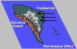
Image 1: The rain shadow effect of the Andes Mountains
II. Rain clouds heading eastward from the Pacific Ocean toward the Atacama Desert are quickened to condensation by the cold Humboldt Current from the Southern Ocean, which induces precipitation at sea before the clouds can reach the western coast of South America. The only moisture reaching the Atacama is the morning mist that typically enshrouds its arid coastline.

Image-2: Satellite Image of Atacama Region showing the morning maritime coastal mist blanketing the coastline (far left).
The hyper-aridity at Nazca results not only in the absence of water erosion but also in the absence of physical and chemical weathering associated with the activity of plants, animals, and microorganisms. Life’s dependency on water is gravely evident at Nazca. The extremely dry environment is so hermetic that whatever is interred there after death is preserved in a state of natural mummification that resists decomposition.
In addition to the hyper-arid condition, the Nazca Plateau has chemical properties that further increase its biological inhospitality. Compounds of Mercury and Lead, generally toxic, can be found in the mineral amalgam that makes up the Nazca terrain. The magnified biological deterrence resulting from this rare combination of hyper-aridity and toxicity is evident in the lack of earthbound creatures seen crossing the open plain—an owl, beetle, or one’s own shadow are at times the only reminders of life’s fluid existence. The lifeless stillness of the Nazca Plateau preserves the geoglyphic design engraved on it—otherwise, even something as small as ants would disturb the earth and the graven record it bears.
Nazca’s biological inhospitality might seem to have an erosive drawback, as it results in an absence of trees or other vegetation to shield its surface from the wind. Yet the lifeless, treeless plain raises a different type of shield against the wind’s marring power. The Nazca Plateau falls under the geologic category of a marl: a loose conglomerate of calcium or magnesium carbonate and clays. Marls are generally grey, yet their color may be influenced by other minerals such as iron oxides, as is the case with Nazca. The iron-rich earth at Nazca has the particular property of absorbing solar energy and steadily radiating it upwards into the air above it. Even in hours of darkness, the heated iron generates a boundary layer of warm air that rises several inches above the surface. This blanket of rising hot air functions as a shield that prevents the wind from contacting the surface and the ancient record.
In the event wind breaches the thermal shield, Nazca presents yet another hermetic coat of armor. The marl includes gypsum in its mineral mixture. Gypsum (a.k.a. hydrated calcium sulfate: CaSO4 x 2H2O) is a soft mineral salt used to make chalk, fertilizers, cements, and plaster of Paris. The concentration of gypsum in the Nazca marl is sufficient for the ground to self-adhere—a quality that makes it more akin to asphalt than to loose earth. The increase in surface friction is readily notable, resulting in an adhesion between mutually contacting pebbles that is far greater than expected from weight and surface roughness alone. The bonding effect of gypsum is periodically renewed—the morning mists produced by the cold Humboldt current soften the adhesive, which then re-hardens in the day’s heat, regenerating the seal.
The overview of the Nazca’s natural hermetic factors concludes with one that is both natural and artificial, as it involves the natural human inhabitants of the Nazca region. Local folklore recounts that long before the Spanish or even the Incas arrived to conquer, there was a time of terrible geologic and atmospheric upheaval. When the turmoil passed, as goes the story, a group of foreigners made their way through the Andean region. Among the things accredited to them was the authorship of the geoglyphic lines and figures on the Nazca Plateau. According to the lore, upon the request of the foreigners, the people of Nazca swore an oath to “walk” the lines on their behalf. An oath which they apparently honored for millennia, for this was reported by the Spanish conquistadors who witnessed and recorded the act of line walking. This “line walking’’ would hypothetically reprove the lines and prevent the accumulation of iron oxides on the disturbed areas, thus preventing loss of the visual contrast that creates the lines. Many people think such tales are not true. Instead of disputing the authenticity of these stories, they would be better served by first scientifically proving that the Nazca Lines are not an ancient map. We openly and amiably challenge people to do so, for if the lines and figures engraved on the plateau are an ancient map, then such stories have found their true reason. Regardless, it is our hope this work helps to illuminate the debt owed them and to all wise and patient keepers of the past.
III. Her Measured Scale
If one begins with the premise that the physical characteristics of any functional design are manifestations of its intended purpose—its form defining its function—one can infer the functional purpose of the Nazca Geoglyphic Anomaly from its form.
Considering the form of the geoglyphic anomaly itself. Each geoglyphic figure consists of a single continuous line—the furrowing instrument that made them remained in contact with the ground throughout the entire outline of each figure and length of each straight line. This simple unilinear outline method of drawing betrays the need for permanence— a unilinear outline is easier to walk upon without disturbing its form and therefore easier to re-inscribe.
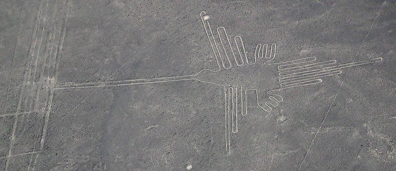
Image-3: The unilinear graphical outline of a hummingbird.
The scale of the geoglyphic anomaly and its individual elements also speaks of longevity as the intention of those that made the map. Any local disturbance to the graphic design would be rendered insignificant in relation to the enormity of its scale. If a line that is miles long lost a segment, was directionally marred by seismic activity, or lost visual contrast from the centuries past in the burning sun, it would still persist. The longer the line is, the more likely it is to retain its overall straightness and visibility.
The enormous scale grants one more unique magnified attribute to the design: enhanced angular resolution. For a line of any given thickness, the longer it is, the more certain one can be of its angular orientation—its heading.
The Nazca Geoglyphic anomaly may initially appear a muddle of randomly oriented lines and figures, but careful observation unveils its subtle order. The majority of the straight lines converge upon specific locations on the plateau. These radial centers are associated with what appear to be artificial mounds or elevations. The great majority of the lines have at least one end terminating at or near one of the radials.

Image-4: Radial center and mound.
The enormity of scale and the design of its individual elements do not suggest an overly pious religious expression of graphical prayers to the gods. It speaks of meticulous precision and the need to keep fidelity with its original form, in spite of time.
Angles are a mathematical and technical concept. The concept that a scientific and technical purpose underlies the Nazca geoglyphic anomaly was proposed by the mathematician Dr. Maria Reiche. Maria Reiche arrived at Nazca shortly after the discovery of the markings by the modern world and remained there for the rest of her life. She drew the world’s attention towards the monument’s mysterious magnificence and the need for its physical protection. The “Lady of the Lines”, as the locals respectfully called her, spent over five decades living on the Nazca Plateau, patiently measuring, recording, and diagramming the geoglyphic enigma. Her analysis led her to the conviction that the pattern had scientific significance and hypothesized that it involved directional alignments with astronomical phenomena, like many megalithic structures such as standing stone circles and Mayan pyramids. Her hypothesis led to an analysis of the lines and polygons of the Nazca Plateau assisted by early computers, satellite imagery, and the collaboration of the Smithsonian Institute . The testing included the celestial sphere as it is in the current era, as well as its orientation in ages past—taking into account the slow but steady rotation of the celestial sphere due to the Axial Precession (Equinoctial Precession) of Earth’s rotational axis. Although the celestial alignment hypothesis did not yield significant statistical results, Dr. Reiche remained convinced of the scientific import of the inscription. She never abandoned the endeavor to find the geoglyphic anomaly’s significance and to ensure its respectful protection and preservation. Her mathematical and scientific approach to the analysis of the pattern brought legitimacy and respectability to the study of the Nazca anomaly and to the field of archeology in general. This present work owes much to the Lady of the Lines.
Maria Reiche thought that the lines and angles at Nazca implied a level of angular technicality and directional orientation that were suggestive of astronomical alignments. Nazca has many lines that radiate from relatively few radial centers at various headings…Radial Centers…angles…headings. These terms invoke thoughts regarding maps and navigation. Particularly the enigmatic “Portolan Charts”. These portolan maps have been investigated and addressed in the past by A.E. Nordenskiold, and Charles H. Hapgood and his students*. Their published analyses are strongly recommended as introductions to portolan charts, ancient cartography, and cartography in general.
Portolan Charts are navigation maps that made their historical appearance during the Renaissance. A few of those maps display mysterious anomalies (about which we have much to say, but it must wait for another day), but one might say their most salient characteristic is the difference in their cartographic grids in comparison to the familiar maps of our present era. Modern maps are generally Mercator Cylindrical Projections. Mercator maps have a Cartographic Grid based on lines of latitude and longitude that meet each other at perpendicular angles, creating the familiar rectangular grids seen on modern wall maps.
Portolan maps have cartographic grids determined by vector lines emerging at regular angular intervals from radial centers traditionally called “Wind Roses”.
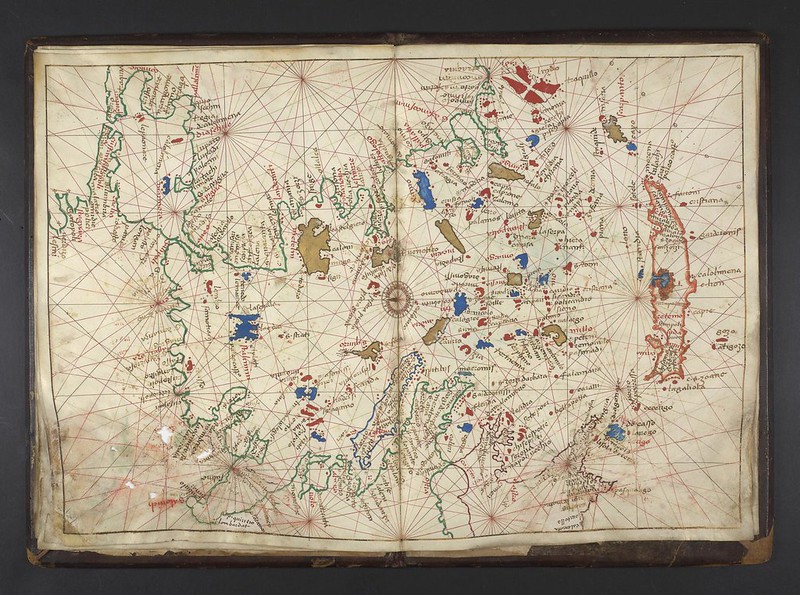
Image-5: Portolan Map
The grid of portolan charts is dominated by the radial vector lines patterns that emanate from their wind roses…much like the radial centers of the Nazca geoglyphic anomaly.
Thus we have a nascent hypothesis: The Nazca Lines are a map that was intended to last a very long time.
Thus begins what here is humbly presented: The Nazca Great Circle Map Hypothesis and its scientific proof.