The Nazca Solution
The Nazca Solution team would like to welcome you to our portal and hope that you find its contents intriguing.
For many of us, the mysteries of the past have inspired awe and wonder, presenting questions which encourage investigation and exploration.
The Nazca Great Circle Map Hypothesis and its experimental proof, presented here, is the result of our ongoing and open investigation.
As a map, the Nazca Lines hold within them the imprint of the unique perspective of those who charted it. As a map of the Earth, that perspective—a global perspective—seems to have been as relevant in the distant past as it is today.
Hypothesis: The Nazca Lines are a Global Great Circle Map
VISUAL summary of the Nazca Great Circle Map Hypothesis:
The following image is the blueprint of the geoglyphic diagram known as the Nazca Lines, which we propose is a great circle map:
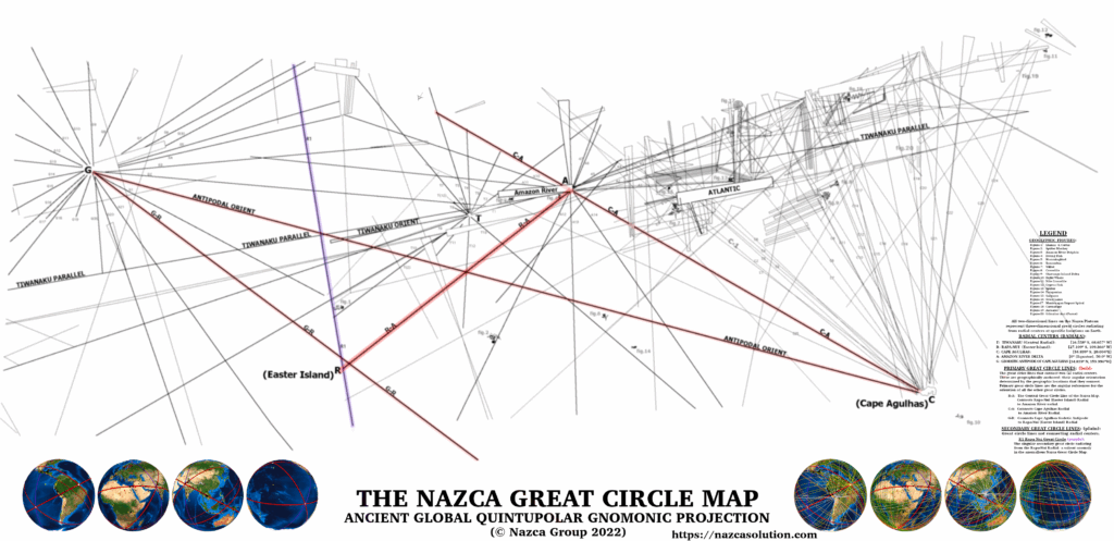
The two-dimensional (2D) lines of the Nazca geoglyphic diagram shown above
Represent
the three-dimensional (3D) great circles projected on the spherical Earth shown below
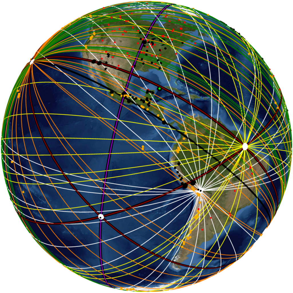
The Global Construct of Great Circle Alignments
The Nazca Lines projected as circumscribing great circles on the terrestrial sphere.
Ancient Structural Sites [BLACK], ultra prominent volcanoes [ORANGE], Impact Craters [RED]
VERBAL summary of the Nazca Great Circle Map Hypothesis:
The diagram of geoglyphic lines and figures drawn on the Nazca Plateau represents a great circle map of Earth. The two-dimensional lines of the Nazca map represent three-dimensional circles called great circles, which can be imagined as virtual rings that circumscribe the Earth—with their planes intersecting its center. In other words, the geometric center of a great circle is the center of the Earth. Most of the lines at Nazca radiate from five (5) foci on the plateau, called radial centers, or simply, radials.
Most of the geoglyphic figures represent biota that are endemic to a particular region of the Earth or belong to a specific ecological zone. As such, they function as geographic specifiers, allowing the identification of different regions of the Earth, similar to the toponyms (place names) on modern maps that identify geographical features, making them cartographically sensible. Using the geoglyphic figures, the five geographic locations represented by the five radials of the map can be inferred.
The lines that connect adjacent radial centers to each other are called primary great circle lines, and the great circles they represent are called primary great circles. Once the geographic locations of the radials are deciphered, one can project the primary great circles by connecting the geographic radial locations with them. The angular inclination of these primary great circles is determined by the geographic point locations they connect. These primary great circles are therefore “geographically anchored” to the Earth, providing a fixed angular framework that serves as the angular reference by which all the other great circles—called secondary great circles—can be oriented. By measuring the angle between a two-dimensional secondary great circle line on the map in relation to a primary line, one can project the corresponding secondary great circle at that same angle in relation to the corresponding primary great circle. In this manner, one can project all the two-dimensional lines of the Nazca Map as great circles on a three-dimensional terrestrial sphere (globe), as shown above in Spherical Projection-1.
A great circle of extraordinary sites:
Once the lines are projected as their corresponding great circles, a pattern emerges: Most of Earth’s major volcanoes, impact craters, and extraordinary ancient structures and settlements (ancient structural sites)—of some of our earliest known civilizations—are found aligned along the courses of the great circles.
The central primary great circle of the Nazca map, labelled R–A in Plate-1, was initially discovered by Jim Alison, independently and without using the Nazca Great Circle Map. Jim Alison noticed the linear relationship of the ancient sites empirically through observation and realized that they were aligned in a great circle’s course. Upon realizing that the Nazca Plateau with its geoglyphic diagram of straight lines was one of the extraordinary sites found on the great circle’s course, he conjectured that perhaps the geoglyphic lines represented a great circle map.
The discovery of the map’s central primary great circle by independent researchers and the arrival at the same conclusion—that the Nazca Lines represented a great circle map—is an example of scientific corroboration and one of the most fortunate things that can occur in the pursuit of truth.
We call this central great circle, the Cyclopean Great Circle, due to the cyclopean masonry of many of the structures found at the ancient sites aligned with its course. Some of the world’s most impressive ancient monuments and cradles of civilization are in great circle alignment with this circle. The term “great circle alignment” was coined by Jim Alison to describe this ancient geographic and cartographic phenomenon: of ancient monuments and settlements placed along great circle paths to generate a global pattern. We call the entirety of the great circles of the Nazca Map and the ancient sites aligned with them, the ancient “global construct of great circle alignments”.
Click the link below this image for an Object VR of the Cyclopean Great Circle Alignment.
See an interactively rotatable view on our Virtual Cyclopean Circle page.
The ancient structural sites, impact craters, and ultra-prominent volcanoes (those with a peak prominence ≧ 1500 meters) which form part of the Cyclopean Great Circle Alignment are the following:
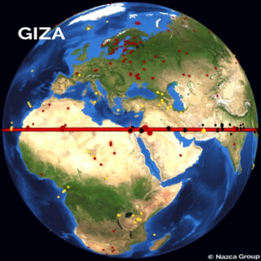
The Giza Plateau and the Upper Nile Delta; the city of Petra and the nearby Neolithic settlement of Beidha; Saqqar Impact Crater; Jabal Waqf es Swwan Impact Crater; Eridu and Ur; Naqsh-e-Rostam and Tangeh Bolaghi (Bolaghi Gorge: ancient settlements dating as far back as 5000 BCE); ultra volcano Taftan ; Shahr-e Sukhteh; Mohenjo-Daro; Mehrgarh; Ganweriwala; Boha Geoglyphs; Ganeshwar; Kajuraho; Mada Caves; Varanasi; Tigra Megaliths; Klaiktiyo Pagoda Rock; Ramanadessa; Sukhothai; Phimai; Prasat Ta Muen Thom; Angkor Wat; Angkor Thom; Preah Vihear; ultra volcano Karangetang; ultra volcano Doma Peaks; Rapa Nui (Easter Island); Paracas-Candelabro geoglyph; the Nazca Plateau; Machu Picchu; Sacsayhuaman; Rio Branco Geoglyph; ultra volcano Pico do Fogo; ultra volcano Topo da Coroa; Aouelloul Impact Crater; Amguid Impact Crater; Tim Bider impact crater…and returning to Giza, completing the great circle’s course.
NOTE: The Nazca Plateau itself is transected by the Cyclopean Great Circle—the map indicating itself with its own great circle is a self-validating characteristic—confirming it has been properly identified and deciphered as a great circle map.
The pyramids of Giza are the largest megalithic masonry monuments ever made and are placed at the mouth of Earth’s longest river, which happens to be equatorial. Eridu is considered the oldest city of Sumer, which is considered the most ancient of known civilizations. Mohenjo Daro, along with Harappa, is one of the oldest cities of the Indus Valley. The Angkor Temple Complex, which includes the temples of Angkor Wat, Angkor Thom, Preah Vihear, and Phimai, among others, is considered the largest temple complex ever built. Rapa-Nui (Easter Island) is one of the most isolated islands on Earth. As it circumscribed the globe, the great circle traverses several geographic extremes: the deltas of Earth’s longest river—the Nile—and Earth’s largest river—the Amazon—as well as the confluence of the Tigris and Euphrates, and the deltas of the Indus and Ganges Rivers of the Indian Subcontinent.
The many great rivers that are traversed by this singular great circle are juxtaposed by the Atacama Desert—the oldest and driest of Earth’s deserts. The Nazca Plateau in particular is the most inert location on Earth—where the largest and oldest of messages was drawn in red sand—a sign and a seal engraved to endure unchanged across time so vast—only the Earth could bear and witness.
The Great Cyclopean Circle exemplifies and establishes the theme of the remarkable ancient map and the extraordinary locations that are aligned with its great circles. It is the theme of those that made it and of the untold loss that must have occurred to inspire such extraordinary efforts, that the resulting works catch the attention of all that encounter them, entangling it in the inescapable net of Earth’s all-encompassing story. The theme of that which is anomalous and extreme.
You can view the entire global construct of great circles of the Nazca Map on our Virtual Nazca Earth Map, which uses Google Maps to graphically present the lines as great circles and all the locations used in the null hypothesis simulation experiment that constitutes the scientific testing of the map.
The work presented in these pages is divided into three sections:
Part I: The Nazca Great Circle Map Hypothesis. Explains how to read the two-dimensional Nazca great circle map and convert it into its three-dimensional great circle form.
Part II: The Random Simulation Experiment . The Statistical Analysis/Experiment section presents the proof of the hypothesis using the Random Simulation Experiment. The Random Simulation is a computer program which tests the great circles of the map for alignment with the major volcanoes, impact craters, and ancient monuments of Earth by comparison with random great circles. The simulation follows and is equivalent to the scientific method of testing known as a “null hypothesis experiment“.
Part III: The Geoglyphic Code. Presents the visual evidence that the Nazca geoglyphs represent topographic and bathymetric contours of certain parts of Earth’s surface, similar to the contour drawing style of common maps. The indication of the topography of submerged terrain implies that it once was dry land. It further implies that there are lost locations of interest and importance waiting to be found.
Below is a short video where we visually explain the key concepts. It may be useful to view this before diving into the hypothesis. We also have an Introduction page which provides background information on various relevant topics such as the Nazca Plateau itself, the physical nature of the Nazca lines, the work of Dr. Maria Reiche, portolan maps, and more.